A model developed by Alonso in the 1960s to explain the paradox observed in many cities that poor people tend to live close to the city centre on high-value land, while the rich occupy cheaper land close to the city margins (see BID-RENT CURVE, URBAN DENSITY GRADIENT). The explanation is based on the assumption that the income of a household is consumed by three basic costs: (i) subsistence (food, etc.); (ii) housing and (iii) COMMUTING (assuming that, for most people, their place of work is located in or near the city centre). Poor households can make a saving on these costs by: opting for an innercity residential location (so as to be close to their work); limiting the amount of highcost space occupied (i.e. by living at high densities); occupying older and often substandard housing, and by accepting MULTIFAMILY OCCUPATION of dwellings. Conversely, rich families are assumed to have large space requirements. Because they can afford higher commuting costs, they are also able to purchase large amounts of the lower-value land to be found at the edge of the city.
Category Archives: WORD OF THE DAY
ALLUVIUM
This describes the SEDIMENTS laid down by streams. Alluvium is unconsolidated material forming features such as ALLUVIAL FANS, FLOOD PLAINS, RIVER TERRACES and DELTAS. The most common constituents are CLAY and SILT (from the SUSPENDED SEDIMENT LOAD of the stream) and SAND and GRAVEL (from the BED LOAD of the stream). Alluvium is generally regarded as being very fertile and it has the potential to form rich farmland.

ALLUVIAL FAN
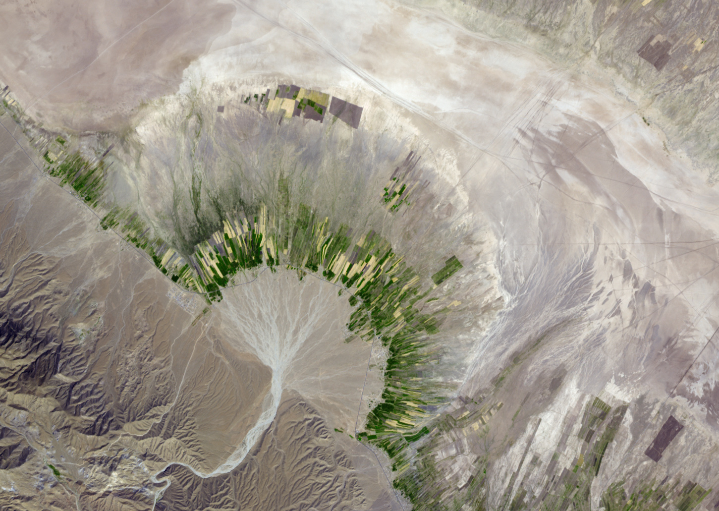
A fan-shaped mass of ALLUVIUM (SAND, GRAVEL, COBBLES and sometimes BOULDERS) formed where a rapidly flowing stream leaves a steep and narrow valley and enters a lowland or broad valley. At such points a reduction in gradient, and thus stream velocity, occurs, causing overloading and DEPOSITION. Alluvial fans form in many different locations – for example, where a small tributary valley joins a major glacial trough, or where a desert stream passes through the MOUNTAIN FRONT to the PIEDMONT Zone.

Alluvial fan in southern Iran.
ALBEDO
The reflectivity of a surface, often expressed as a percentage of the solar radiation that falls on the Earth’s surface. The average global albedo is about 34% (i.e. that percentage of the total solar radiation reaching the Earth’s surface is reflected back into the atmosphere). However, albedo values vary greatly from place to place depending on the precise nature of the surface (ice, snow, different types of vegetation, etc.). The albedo for fresh clean snow exceeds 80%, but is much reduced for coarsely crystalline glacier ice (50%). For grassland, the albedo ranges between 30% and 20%, and for a dark peaty soil it is less than 10%. Water generally has a low albedo (between 5% and 10%) unless the Sun is at a low angle, when the albedo can be in excess of 50%.

AGROFORESTRY
The integrated use of land for agriculture and forestry. For example, the phased planting and felling of WINDBREAKS in agricultural areas prone to wind erosion, or the planting of trees on farmland to raise soil fertility by nitrogen fixing and the supply of leaf litter. It is being encouraged in those LEDCS where the search for fuelwood is causing the serious depletion of timber resources.

Agroforestry – how it works.
AGROCHEMICALS
Chemical inputs in farming that are used to increase productivity by fertilizing the soil, and controlling pests and diseases (pesticides, herbicides and fungicides). There is increasing concern about their use, with mounting evidence of damage to the environment, wildlife and human health.

Massive usage of agrochemicals is a big problem in the US.
AGRICULTURE
Used in a wide sense to include the growing of crops and the rearing of livestock – the whole science and practice of farming. However, some restrict the term to the growing of crops alone.

Rice cultivation at a paddy field in Bihar state of India.
AGRICULTURAL GEOGRAPHY
The description and explanation of spatial variations in the character and productivity of AGRICULTURE. In terms of description, land use is the most conspicuous aspect of that character. Explanation requires reference to such factors as the behavioural environment of farmers’ decision-making, economic rent, government intervention, land tenure, etc. Today, there is increasing interest in the production side, particularly in the adequacy or otherwise of food supply.

Guilin Rice Terraces, Longji, China
AGRIBUSINESS
A large-scale farming system run on business lines by a relatively small number of companies, most of them TNCS. The term was coined in 1957 by Goldberg and Davis. Besides farming, business interests extend ‘upstream’ to include producing farming inputs such as seeds, chemicals, feedstuffs and machinery, and ‘downstream’ to foodprocessing industries and marketing. Examples of such companies are Monsanto, Unilever and Nestle.
AGGRADATION
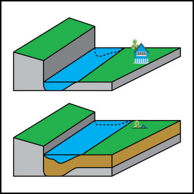
A term used loosely to describe the building up of SEDIMENT by rivers and wave action, hence an aggraded river valley, and aggraded beach profile. More strictly, the term refers to DEPOSITION carried out to restore or maintain the condition of GRADE. For example, an influx of sediment may cause a stream to become overloaded; it will therefore deposit sediment and steepen its course (aggrade), thus increasing its energy and capacity to transport the increased LOAD.

Schematic of sediment accumulation (aggradation) in a river channel. The sediment is brown. The river is flowing on bedrock in the upper image, but because sediment was deposited over time the riverbed has risen. This has caused the house to be buried in the lower image.