Tag Archives: Geology

ALLUVIUM

This describes the SEDIMENTS laid down by streams. Alluvium is unconsolidated material forming features such as ALLUVIAL FANS, FLOOD PLAINS, RIVER TERRACES and DELTAS. The most common constituents are CLAY and SILT (from the SUSPENDED SEDIMENT LOAD of the stream) and SAND and GRAVEL (from the BED LOAD of the stream). Alluvium is generally regarded as being very fertile and it has the potential to form rich farmland.

AFTERSHOCK

Vibration of the Earth’s crust that occurs following an EARTHQUAKE, and results from minor adjustments of rocks along a fault-line after the main rupture. Aftershocks may continue for hours, days or even longer periods of time, and may cause considerable destruction and loss of life where buildings have been weakened by the initial earthquake. There can be hundreds of aftershocks after a major earthquake.

ACTIVE LAYER

In PERIGLACIAL conditions, where PERMAFROST exists, only the upper layer of ground thaws in summer. This upper layer, which is affected by summer thawing and winter freezing, is the active layer. Its lower limit is the permafrost table, which forms an impermeable surface and causes the active layer to be poorly drained. At its maximum, the active layer may reach a depth of 3-6 m, depending on summer temperatures, the duration of the thaw season, soil composition (GRAVEL favours deeper thawing than peaty soils), SOIL MOISTURE and content, and the density of the plant cover. Within the active layer, processes such as SOLIFLUCTION and FROST HEAVE can be highly effective. Engineering structures can become unstable on active layers and, where possible, piles are driven into the permafrost or structures are raised above the ground surface.

LARGE IGNEOUS PROVINCE

A large igneous province, also known as a continental flood basalt, plateau basalt, and trap, is deposits that include vast plateaus of basalts, covering large areas of some continents. They have a tholeiitic basalt composition, but some show chemical evidence of minor contamination by continental crust. They are similar to anomalously thick and topographically high seafloor known as oceanic plateaus and to some volcanic rifted passive margins. in numerous instances over the past several hundred million years these vast outpourings of lava have accumulated, forming thick piles of basalt, representing the largest-known volcanic episodes on the planet. These piles of volcanic rock represent times when the Earth moved more material and energy from its interior than during intervals between the massive volcanic events. such large amounts of volcanism also released large amounts of volcanic gases into the atmosphere, with serious implications for global temperatures and climate and may have contributed to some global mass extinctions.

Zajeta slika

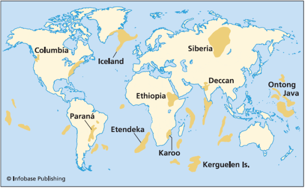
Figure 1: Map of the world showing distribution of flood basalts.

The largest continental flood basalt province in the united states is the Columbia River flood basalt in Washington, oregon, and Idaho. The Columbia River flood basalt province is 6–17 million years old and contains an estimated 4,900 km³ of basalt. individual lava flows erupted through fissures or cracks in the crust, then flowed laterally across the plain for up to 645 km.

The 66-million-year-old Deccan flood basalts, also known as traps, cover a large part of western India and the seychelles. They are associated with the breakup of India from the seychelles during the opening of the indian ocean. slightly older flood basalts (90–83 million years old) are associated with the breakaway of madagascar from India. The volume of the Deccan traps is estimated to be 20,840,000 km³. This huge volume of volcanic rocks erupted over a period of about 1 million years, starting slightly before the great Cretaceous-Tertiary extinction. most workers now agree that the gases released during the flood basalt volcanism stressed the global biosphere to such an extent that many marine organisms had gone extinct, and many others were stressed. Then the planet was hit by the massive Chicxulub impact, causing the massive extinction that included the end of the dinosaurs.

Zajeta slika

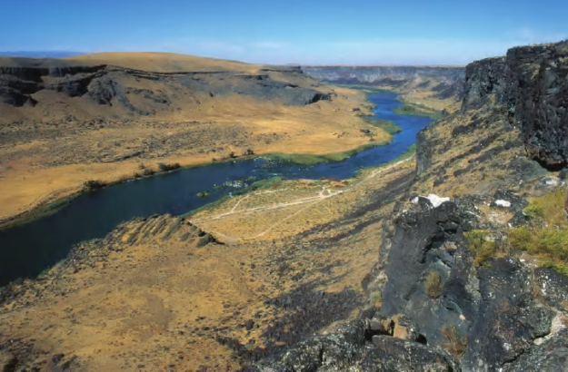
Figure 2: Columbia River flood basalts along Snake River Birds of Prey National Conservation Area near Boise, Idaho (David R. Frazier/Photo Researchers, Inc.)

The breakup of east Africa along the East African rift system and the Red Sea is associated with large amounts of Cenozoic (fewer than 30 million years old) continental flood basalts. Some of the older volcanic fields are located in east Africa in the Afar region of Ethiopia, south into Kenya and Uganda, and north across the Red Sea and Gulf of Aden into Yemen and Saudi Arabia. These volcanic piles underlie younger (fewer than 15-million-year old) flood basalts that extend both farther south into Tanzania and farther north through central Arabia, where they are known as Harrats, and into Syria, Israel, Lebanon, and Jordan.

An older volcanic province, the North Atlantic Igneous Province, also associated with the breakup of a continent, formed along with the breakup of the North Atlantic Ocean at 62–55 million years ago. The North Atlantic Igneous Province includes both onshore and offshore volcanic flows and intrusions in Greenland, Iceland, and the northern British Isles, including most of the Rockall Plateau and Faeroe Islands. The opening of the ocean in the south Atlantic is similar to 129–134-million-year-old flood basalts, which, now split in half, comprise two parts. In Brazil the flood lavas are known as the Paraná basalts, and in Namibia and Angola of west Africa, as the Etendeka basalts.

These breakup basalts are transitional to submarine flood basalts that form oceanic plateaus. The Caribbean Ocean floor is one of the best examples of an oceanic plateau, with other major examples including the Ontong-Java Plateau, Manihiki Plateau, Hess Rise, Shatsky Rise, and Mid-Pacific Mountains. All of these oceanic plateaus contain between 10–40-km thick piles of volcanic and subvolcanic rocks, representing huge outpourings of lava. The Caribbean seafloor preserves 8–21-km thick oceanic crust formed before about 85 million years ago in the eastern Pacific Ocean. This unusually thick ocean floor was transported eastward by plate tectonics, where pieces of the seafloor collided with South America as it passed into the Atlantic Ocean. Pieces of the Caribbean oceanic crust are now preserved in Colombia, Ecuador, Panama, Hispaniola, and Cuba, and some scientists estimate that the Caribbean oceanic plateau was once twice its present size. In either case it represents a vast outpouring of lava that would have been associated with significant outgassing, with possible consequences for global climate and evolution.

The western Pacific Ocean basin contains several large oceanic plateaus, including the 32-km thick crust of the Alaskan-sized Ontong-Java Plateau, the largest outpouring of volcanic rocks on the planet. Having formed in two intervals, at 122 and 90 million years ago, respectively, entirely within the ocean, the Ontong-Java Plateau represents magma that rose in a plume from deep within the mantle and erupted on the seafloor. Estimates suggest that the volume of magma erupted in the first event was equivalent to that of all the magma being erupted at midocean ridges at the present time. Sea levels rose by more than 9 m in response to this volcanic outpouring. The gases released during these eruptions are estimated to have raised average global temperatures by 13°C.

ENVIRONMENTAL HAZARDS OF FLOOD BASALT VOLCANISM

The environmental impact of the eruption of large volumes of basalt in provinces including those described above can be severe. Huge volumes of sulfur dioxide, carbon dioxide, chlorine, and fluorine are released during large basaltic eruptions. Much of this gas may get injected into the upper troposphere and lower stratosphere during the eruption process, being released from eruption columns that reach two to 3–13 km in height. Carbon dioxide is a greenhouse gas and can cause global warming, whereas sulfur dioxide and hydrogen sulfate have the opposite effect: they can cause short-term cooling. Many of the episodes of volcanism preserved in these large igneous provinces were rapid, repeatedly releasing enormous quantities of gases over periods of fewer than 1 million years, and releasing enough gas to change the climate significantly and more rapidly than organisms could adapt. For instance, one eruption of the Columbia River basalts is estimated to have released 9 billion tons of sulfur dioxide and thousands of millions of tons of other gases, whereas the eruption of Mount Pinatubo in 1991 released about 20 million tons of sulfur dioxide.

The Columbia River basalts of the Pacific Northwest continued erupting for years at a time, for approximately 1 million years. During this time the gases released would be equivalent to that of Mount Pinatubo every week, maintained for decades to thousands of years at a time. The atmospheric consequences are sobering. Sulfuric acid aerosols and acid from the fluorine and chlorine would form extensive poisonous acid rain, destroying habitats and making waters uninhabitable for some organisms. At the very least the environmental consequences would be such that organisms were stressed to the point that they would be unable to handle an additional environmental stress, such as a global volcanic winter and subsequent warming caused by a giant impact.

Faunal extinctions have been correlated with the eruption of the Deccan flood basalts at the Cretaceous- Tertiary (K/T) boundary, and with the Siberian flood basalts at the Permian-Triassic boundary. There is still considerable debate about the relative significance of flood basalt volcanism and impacts of meteorites for extinction events, particularly at the Cretaceous-Tertiary boundary. Most scientists would now agree, however, that global environment was stressed shortly before the K/T boundary by volcanic-induced climate change, and then a huge meteorite hit the Yucatán Peninsula, forming the Chicxulub impact crater and causing the massive K/T boundary extinction and the death of the dinosaurs.

The Siberian flood basalts cover a large area of the Central Siberian Plateau northwest of Lake Baikal. They are more than half a mile thick over an area of 543,900 km² but have been significantly eroded from an estimated volume of 3,211,600 km³. They were erupted over an extraordinarily short period of fewer than 1 million years, 250 million years ago, at the Permian-Triassic boundary. They are remarkably coincident in time with the major Permian-Triassic extinction, implying a causal link. The Permian-Triassic boundary at 250 million years ago marks the greatest extinction in Earth history, when 90 percent of marine species and 70 percent of terrestrial vertebrates became extinct. It has been postulated that the rapid volcanism and degassing released enough sulfur dioxide to cause a rapid global cooling, inducing a short ice age with associated rapid fall of sea level. Soon after the ice age took hold, the effects of the carbon dioxide took over and the atmosphere heated to cause global warming. The rapidly fluctuating climate postulated to have been caused by the volcanic gases is thought to have killed off many organisms, which were simply unable to cope with the wildly fluctuating climate extremes.

ACCRETION

A process of growth by accumulation; e.g. the enlargement of a raindrop by collision with many other tiny water droplets within a cloud, or the accumulation of mineral matter in a particular location, e.g. sand on a beach.

Zajeta slika

GPR profiles: ( a ) along the relict sand accretion bar crest (1, cross-bedding sands; 2, horizontal bedding sands; 3, unsorted sands of the first stage of accretion; 4, lagoon clayey sands; 5, buried soils; 6, medium- to fine-grained aeolian sands; 7, GPR profile).  Development of the coastal systems of the easternmost Gulf of Finland, and their links with Neolithic–Bronze and Iron Age settlements.


ABYSSAL PLAIN

A term applied to the deepest parts of the ocean floor (mainly between 2200 and 5500 m), on which fine-textured deposits (ooze) have accumulated to considerable thicknesses over long periods of geological time. Lying for the most part between the foot of a mainland rise and a mid-sea edge, deep fields cover more than half of the Earth’s surface. They are among the flattest, smoothest and slightest investigated areas on Earth.

Abyssal plains were not recognized as distinct physiographic features of the sea floor until the late 1940s and, until very recently, none had been studied on a systematic basis. They are poorly preserved in the sedimentary record, because they tend to be consumed by the subduction process. The creation of the abyssal plain is the end result of spreading of the seafloor (plate tectonics) and melting of the lower oceanic crust. Magma rises from above the asthenosphere (a layer of the upper mantle) and as this basaltic material reaches the surface at mid-ocean ridges it forms new oceanic crust. This is constantly pulled sideways by spreading of the seafloor. Abyssal plains result from the blanketing of an originally uneven surface of oceanic crust by fine-grained sediments, mainly clay and silt. Much of this sediment is deposited by turbidity currents that have been channelled from the continental margins along submarine canyons down into deeper water. The remainder of the sediment is composed chiefly of pelagic sediments. Metallic nodules are common in some areas of the plains, with varying concentrations of metals, including manganese, iron, nickel, cobalt and copper. These nodules may provide a significant resource for future mining ventures.

HOW DO DIAMONDS TRANSPORT FROM MANTLE?

HOW ARE DIAMONDS FORMED?

Diamonds are formed deep within the Earth about 160 kilometres or so below the surface in the upper mantle. Obviously in that part of the Earth it’s very hot. There’s a lot of pressure, the weight of the overlying rock bearing down, so that combination of high temperature and high pressure is what’s necessary to grow diamond crystals in the Earth. As far as we know, all diamonds that formed in the Earth formed under those kinds of conditions and, of course, that’s a part of the Earth we can’t directly sample. We don’t have any way of drilling to that depth or any other way of traveling down to the upper mantle of the Earth.

HOW DO DIAMONDS TRAVEL TO THE SURFACE OF THE EARTH?

The diamonds that we see at the surface are ones then that are brought to the surface by a very deep-seated volcanic eruption. It’s a very special kind of eruption, thought to be quite violent, that occurred a long time ago in the Earth’s history. We haven’t seen such eruptions in recent times. They were probably at a time when the earth was hotter, and that’s probably why those eruptions were more deeply rooted. These eruptions then carried the already-formed diamonds from the upper mantle to the surface of the Earth. When the eruption reached the surface it built up a mound of volcanic material that eventually cooled, and the diamonds are contained within that. These are the so-called Kimberlites that are typically the sources of many of the world’s mined diamonds.

Diamond-bearing rock is carried from the mantle to the Earth’s surface by deep-origin volcanic eruptions. The magma for such a volcano must originate at a depth where diamonds can be formed—150 km or more (three times or more the depth of source magma for most volcanoes). This is a relatively rare occurrence. These typically small surface volcanic craters extend downward in formations known as volcanic pipes. The pipes contain material that was transported toward the surface by volcanic action, but was not ejected before the volcanic activity ceased. During eruption these pipes are open to the surface, resulting in open circulation; many xenoliths of surface rock and even wood and fossils are found in volcanic pipes. Diamond-bearing volcanic pipes are closely related to the oldest, coolest regions of continental crust. This is because cratons are very thick, and their lithospheric mantle extends to great enough depth that diamonds are stable. Not all pipes contain diamonds, and even fewer contain enough diamonds to make mining economically viable. Diamonds are very rare because most of the crust is too thin to permit diamond crystallization, whereas most of the mantle has relatively little carbon. 

The magma in volcanic pipes is usually one of two characteristic types, which cool into igneous rock known as either kimberlite or lamproite. The magma itself does not contain diamond; instead, it acts as an elevator that carries deep-formed rocks (xenoliths), minerals (xenocrysts), and fluids upward. These rocks are characteristically rich in magnesium-bearing olivine, pyroxene, and amphibole minerals which are often altered to serpentine by heat and fluids during and after eruption. Certain indicator minerals typically occur within diamantiferous kimberlites and are used as mineralogical tracers by prospectors, who follow the indicator trail back to the volcanic pipe which may contain diamonds. These minerals are rich in chromium (Cr) or titanium (Ti), elements which impart bright colors to the minerals. The most common indicator minerals are chromium garnets (usually bright red chromium-pyrope, and occasionally green ugrandite-series garnets), eclogitic garnets, orange titanium-pyrope, red high-chromium spinels, dark chromite, bright green chromium-diopside, glassy green olivine, black picroilmenite, and magnetite. Kimberlite deposits are known as blue ground for the deeper serpentinized part of the deposits, or as yellow ground for the near surface smectite clay and carbonate weathered and oxidized portion. 

Once diamonds have been transported to the surface by magma in a volcanic pipe, they may erode out and be distributed over a large area. A volcanic pipe containing diamonds is known as a primary source of diamonds. Secondary sources of diamonds include all areas where a significant number of diamonds have been eroded out of their kimberlite or lamproite matrix, and accumulated because of water or wind action. These include alluvial deposits and deposits along existing and ancient shorelines, where loose diamonds tend to accumulate because of their size and density. Diamonds have also rarely been found in deposits left behind by glaciers (notably in Wisconsin and Indiana); in contrast to alluvial deposits, glacial deposits are minor and are therefore not viable commercial sources of diamond.

WHAT IS CARBON’S ROLE IN FORMING DIAMONDS?

Diamonds are made of carbon so they form as carbon atoms under a high temperature and pressure; they bond together to start growing crystals. Because of the temperature and pressure, under these conditions, carbon atoms will bond to each other in this very strong type of bonding where each carbon atom is bonded to four other carbon atoms. That’s why a diamond is such a hard material because you have each carbon atom participating in four of these very strong covalent bonds that form between carbon atoms. So as a result you get this hard material. Again where the carbon is coming from, how quickly they’re growing, those are all still open questions, but obviously the conditions are such that you’ve got some group of carbon atoms that are in close enough proximity that they start to bond. As other carbon atoms move into the vicinity they will attach on. That’s the way any crystal grows. It’s the process of atoms locking into place that produces this repeating network, this structure of carbon atoms, that eventually grows large enough that it produces crystals that we can see. Each of these crystals, each diamond, one carat diamond, represents literally billions and billions of carbon atoms that all had to lock into place to form this very orderly crystalline structure.

The Cullinan Diamond is 3,106,75 carats (621.35 grams) diamond and is the largest rough gem quality diamond ever found in the world.